
Hoja antiguo mapa del río Mapas
159 resultados
¡MAPA DE LA GUERRA CIVIL DE VTG! ¡FORTIFICACIONES REBELDES EN EL RÍO MISSISSIPPI EN NUEVA MADRID!
₡ 92 380.71₡ 16 751.27 por el envíoMapa geográfico vintage del río Elba Elbin Berlín Alemania 1887 C17-4
₡ 11 116.75₡ 17 852.79 por el envío1878-88 US Coast Survey 3 hojas mapa antiguo muy grande del río Delaware
₡ 278 629.44₡ 10 147.21 por el envío1894 FRANCE HAVRE TO RIVER DURDENT LE HAVRE GENUINO MAPA DE COLECCIÓN DEL ALMIRANTAZGO
₡ 37 577.31₡ 5 413.68 por el envíoESTUARIO DEL RÍO SEINE, Francia Día D Invasión OVERLORD Planificación - Mapa de la Segunda Guerra Mundial 1943
₡ 2 515.77₡ 2 706.84 por el envíoMapa antiguo grande de 1882: delta del río Mississipi a Memphis 13
₡ 6 091.37₡ 16 487.31 por el envíoMAPA SUDANÉS DE TIERRAS BLANCAS DEL RÍO NILO 1919 100 X 50 CM
₡ 25 380.71₡ 5 076.14 por el envíoAnuncio nuevoMapa WYOMING 1877 ORIGINAL Green River Basin Montañas Rocosas raíz amarga
₡ 14 659.90₡ 14 456.85 por el envíoSouth Fork American River Water Project 1978 Placerville Sierra Nevada mapas topográficos
₡ 30 451.780 ofertas de subasta₡ 46 700.51 por el envíoFinaliza en Hoy a la(s) 7:30PM CST10 h 49 minMapa del río Támesis Shepperton vía Walton on Thames and Sunbury Taunt 1885
₡ 53 499.90₡ 6 655.64 por el envíoRiver Thames Burcott Little Wittenham Dorchester Shillingford Henry Taunt 1885
₡ 42 035.63₡ 6 655.64 por el envío1807 Ataque del río Yorktown en Virginia por JOHN MARSHALL, MAPA de la guerra revolucionaria
₡ 304 568.53₡ 30 598.98 por el envíomapa del río Támesis Streatley y Goring a Basildon Taunt 1885
₡ 53 952.10₡ 6 655.64 por el envíoMapa original vintage 1948 de Arnhem y los tres ríos 8,25"" x 5"" batalla de la Segunda Guerra Mundial
₡ 12 738.07₡ 5 190.76 por el envíoMapa fluvial de la expedición de Tehuantepec 1871 52"" x 22,5"" carta del río Coatzacoalcos
₡ 16 243.65₡ 14 502.54 por el envío1895 MAPA DE CARTA DEL ALMIRANTAZGO DE COLECCIÓN RÍOS DE LA COSTA OESTE DE ÁFRICA DE COLECCIÓN
₡ 50 315.38₡ 7 324.39 por el envíoMapa militar naval de San Alemania o Lynher River; Saltash, Cornualles Segunda Guerra Mundial 1944
₡ 2 222.79₡ 2 515.77 por el envíoMAPA DE SUDANÉS MAPA CLAVE DEL RÍO NILO - AHGLO - EGIPCIO 1920
₡ 25 380.71₡ 5 076.14 por el envíoMAPA SUDANÉS GEBEL AULIA DAM 1918
₡ 25 380.71₡ 5 076.14 por el envíoMapa del río Támesis North Stoke Little Stoke Moulsford South Stoke por Taunt 1885
₡ 42 035.63₡ 6 655.64 por el envío1892 río Volga cerca del plano de Saratov, estampado antiguo Rusia
₡ 8 629.44₡ 4 060.91 por el envíoMapa antiguo del río Támesis de Taunt c1885 de Ashton Keynes a Cricklade
₡ 50 315.38₡ 6 655.64 por el envíoMapa antiguo ""Carta del río Cooks en el nuevo noroeste parte de América"" A. Hogg, 1778
₡ 38 214.21₡ 11 464.26 por el envío#41509 Mapa vintage montañas Khin-Gan [China]. Royal Geog.Society Inglaterra 1898.
₡ 9 553.55₡ 2 547.61 por el envíoMAPA ASSUAN (Egipto), Isla Philae Templo de Isis 15 X 20 cm
₡ 12 690.36₡ 4 568.53 por el envío3 - Mapas de ríos y arroyos de roca Potomac anacostia Washington DC C. década de 1880
₡ 177 659.90₡ 26 873.10 por el envío#41974 Mapa vintage del río Benue [África occidental]. Royal Geog.Society Inglaterra 1899
₡ 9 553.55₡ 1 910.71 por el envíoPlano de depósitos de almacenamiento Vyshny Volochyok 1892, estampado antiguo Rusia
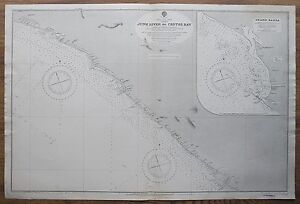
₡ 8 629.44₡ 4 060.91 por el envío1907 LIBERIA JUNK RIVER TO CESTOS BAY GRAND BASSA VINTAGE MAPA GRÁFICO DEL ALMIRANTAZGO
₡ 18 470.20₡ 7 324.39 por el envío1905 FRANCE RIVER DURDENT TO CAYEUX DIEPPE GENUINO DE COLECCIÓN MAPA DEL ALMIRANTAZGO
₡ 63 053.45₡ 7 324.39 por el envío1880 LIBERIA CAPA MESURADO A BAFFU BAY JUNK RIVER DE COLECCIÓN MAPA DEL ALMIRANTAZGO
₡ 19 107.11₡ 7 324.39 por el envío1856 Cabo Florida a Isla Tortugas MAPA Boceto de Encuesta de Costa de EE. UU. F - 33""x 23""
₡ 12 182.74₡ 21 994.92 por el envíoMAPA DE SUDANÉS PROPONADO PRESA SENNAR PLANO DE SITIO 1918
₡ 25 380.71₡ 5 076.14 por el envíoMAPA SUDANÉS ESQUEMA DE RIEGO GEZIRA 1920.
₡ 25 380.71₡ 5 076.14 por el envíoMapa del río Támesis por Taunt c1885 Palacio y parque de Hampton Court Kingston
₡ 42 640.69₡ 5 031.54 por el envíoMapas que muestran la ubicación del trabajo realizado en White River, Arkansas 1896
₡ 15 228.43₡ 19 548.22 por el envíoMapa Eton Windsor Park y en Datchet Mapa Río Támesis Henry Taunt 1885
₡ 52 226.09₡ 6 655.64 por el envíoMAPA DE SUDANÉS ESQUEMA DE RIEGO GEZIRA 1918
₡ 25 380.71₡ 5 076.14 por el envío1945 Mapa de Nanjemoy Maryland - Río Potomac; Bahía de Mallows; Cala Nanjemoy
₡ 38 065.99₡ 15 147.21 por el envíoMapa de estudio del suelo en color hoja de la Gran Isla Nebraska Shelton Wood River Abbott 1903
₡ 4 563.45₡ 34 304.57 por el envíoMAPA DE SUDANÉS ESQUEMA DE RIEGO GEZIRA 1918
₡ 25 380.71₡ 5 076.14 por el envíoRío Támesis Castillo de Trewsbury y Kemble a Ashton Keynes Mapa de Taunt c1885
₡ 45 857.06₡ 6 655.64 por el envíoMAPA SUDANÉS VALLE DEL NILO AZUL DE SINGA A MAKWAR 1920
₡ 25 380.71₡ 5 076.14 por el envíoMAPA SUDANÉS SECCIONES TRANSVERSALES DEL NILO BLANCO 1918
₡ 25 380.71₡ 5 076.14 por el envíoMapa del río Oxford Támesis Osney Lock Folly Bridge Iffley Lock a Kennington 1885
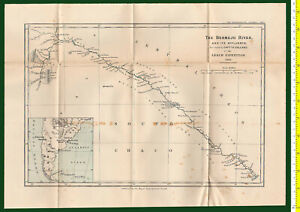
₡ 66 874.87₡ 6 655.64 por el envío#41324 Mapa vintage. South America, Bermejo River Royal Geo. Society England 1900
₡ 10 827.36₡ 2 547.61 por el envíoMapa de cerradura superior de Inglesham a Lechlade y en Buscot río Támesis 1885 burla
₡ 51 684.72₡ 6 655.64 por el envío#41973 Mapa vintage, río Kuyuni superior [Guayana].Royal Geog.Society Inglaterra 1896
₡ 9 553.55₡ 1 910.71 por el envíoMapa del Támesis c1885 Cassington Wytham Godstow Lock on to Binsey cerca de Oxford
₡ 61 142.74₡ 6 655.64 por el envíoMapa Eaton Windsor Park Castle Datchet por Henry Taunt 1885 río Támesis
₡ 59 868.93₡ 5 031.54 por el envíomapa del río Támesis Purley y Mapledurham a Caversham y lectura de Taunt 1885
₡ 42 035.63₡ 6 655.64 por el envíoMapa del río Támesis Brentford Isleworth Richmond por Henry Taunt c1885
₡ 43 309.44₡ 5 031.54 por el envío"Mapa de ratón vintage 1936 USGS Seiad, California Klamath río - 16,5"" x 20"
₡ 10 152.28₡ 13 055.84 por el envíoZapatos de caballo Laleham y en Chertsey Lock Map 27 River Thames mapa 1885 burla
₡ 52 640.08₡ 6 655.64 por el envíoMapa original de 1842 herrero de flechas FUENTES DEL NILO AZUL Ankóber a Gédem Etiopía
₡ 14 208.12₡ 10 807.11 por el envíoHenley to Wargrave and Shiplake Lock River Thames c1885 mapa burla
₡ 50 315.38₡ 6 655.64 por el envíoRío Támesis Taunt 1885 Kelmscott a Eaton Hastings y en el mapa del puente Radcot
₡ 51 684.72₡ 6 655.64 por el envíoMapa de Little Caversham a Sonning y Shiplake río Támesis c1885
₡ 53 499.90₡ 6 655.64 por el envío1904-5 ÁFRICA LIBERIA MANNA RÍO A BASURA RÍO MONROVIA MAPA ANTIGUO DEL ALMIRANTAZGO
₡ 43 946.35₡ 5 413.68 por el envíoCANADÁ, NUEVO BRUNSWICK Y NOVA ESCOCIA, RÍO NIÁGARA, mapa antiguo de Teesdales 1841
₡ 25 444.30₡ 6 050.58 por el envío


![#41509 Vintage map Khin-Gan Mountains [China]. Royal Geog.Society England 1898.](https://i.ebayimg.com/thumbs/images/g/HF8AAOSwTNFfcFzt/s-l300.jpg)


![#41974 Vintage map of Benue River [West Africa]. Royal Geog.Society England 1899](https://i.ebayimg.com/thumbs/images/g/wGUAAOSwlIxfnEHF/s-l300.jpg)


![#41973 Vintage map, Upper Kuyuni River [Guiana].Royal Geog.Society England 1896](https://i.ebayimg.com/thumbs/images/g/g8cAAOSwIy1fnEFQ/s-l300.jpg)


